ATHABASCA – From the ice jam in 1904 that prompted Métis man Billy Loutit to make his historic run from Athabasca to then Fort Edmonton in 16 hours to the most recent flooding, Athabasca has had, at times, a difficult relationship with the river.
As the water breached the banks July 5 people gathered along Riverfront Park to take photos and marvel at how the water was up past trees where just days before, during the Canada Day fireworks, children sat in the boughs to enjoy the light show.
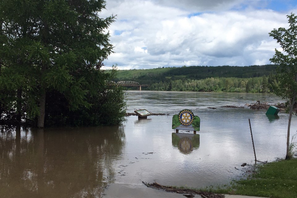
The flood this year is, so far, the seventh highest on record with higher levels in 1944, 1954, 1971, 1980, 1986 and 2011 according to Water Survey of Canada measurements which started in 1913. The information was extracted from the Environment and Climate Change Canada Historical Hydrometric Data web site July 9.
In 1954, when the waters reached their highest to date – 7.94 metres above normal – the Athabasca Echo newspaper reported on the flood.
“At the time of the flood in 1944, town water supply was the crucial point, as the pump house was flooded, but this time the excitement centred about the power plant of Northland Utilities Ltd., and on Thursday morning an urgent appeal for help was sent out via the fire siren for men to help sandbag the building. Many had worked all night in an attempt to safeguard this plant, and following the appeal between three and four hundred flocked to the danger point and got busy."
The article went on to say the lumber companies, grain elevators, seed warehouses, power plant and “numerous homes were the chief victims.” Almost 4,000 sandbags were used and an additional 7,000 were sent from the Civil Defense headquarters in Edmonton.
This latest flood, measuring 6.2 metres above normal, did not cause as much concern for the town itself CAO Rachel Ramey noted July 9.
“Not much you can do when these floods happen. I think it was evident, by what everyone saw, how we were affected. We will have to go in and clean up Rotary Trail again, but the ground is now saturated and too soft for us to get equipment in,” she said.
She added her main worry was the reports of youth jumping into the Tawatinaw River, from the overpass above.
Jamie Giberson, the manager for the Aspen Regional Water Services Commission, said that there was some flooding in the old water treatment plant, the municipal building located at the east side of the Tipton’s Your Independent Grocer parking lot.
“There's probably about three feet of water in the basement. The Environment Canada river level monitoring station is inside the building so, we have a pretty good idea of how high the river is there with their station. If the river reaches that five-metre mark, we could see water in the basement, but this time, I think we were as high as 6.2 metres. So, it was probably the highest I've seen in about 10 or 12 years,” Giberson said.
When the basement floods Giberson said it limits the ability to draw water from the river for treatment for municipal consumption.
“It basically flows by gravity into a big hole in the ground – essentially the well – and then out of that we pump that up the hill to the water plants and we have a storage pond out back and then we draw from that storage pond and treat the water for municipal water,” he said.
Giberson added the storage pond would last about two weeks so there is no need to worry about a shortage of water, even with a flood.
A 2014 feasibility study of the Athabasca Basin by IBI Group and Golder Associates LTD for the Government of Alberta estimated the average annual damage from flooding along the entire basin at $5.75 million.
Included in that study, Fort McMurray was assessed at high risk for future flood damage, which they saw again this spring. Moderate risk was placed on Whitecourt and Slave Lake while Athabasca and Barrhead were listed as low risk and Westlock no risk.
Flooding is not the only thing that happens in a river when water gets high though, says Don Kvill, who taught geology at Athabasca University.
“My actual field is geomorphology and that's why I'm interested in what goes on at the base of the river, not the surface. The velocity increases and the pressure increases so the bed load starts to move. Some bed load is moving all the time; the finer stuff is moving all the time,” Kvill said.
That extra movement creates some physical changes in the river, he explained, including the formation of new sand bars which can prove troublesome for boaters.
“The river pilots years ago would have been very concerned going downstream after a flood because they don't know where the sandbars are. And if you're going downstream, the current is going to push you onto the sand berm not off of it. So, if you run onto one, you're in deep trouble. After the river level drops, there would be a few anxious trips until they got the channel figured out again,” he said.
The extra water also increases the velocity of the river causing erosion on the outside of a bend and silt deposits on the inside which in flatter areas will create meanders and oxbows.
“In an incised valley like the Athabasca is in, which was largely created during de-glaciation, oxbows aren't very common, but if you get into rivers like the Paddle River and the Pembina, they have lots of oxbows and meanders and stuff like this, but that's what creates meanders and meanders create oxbows,” said Kvill.
Kvill threw in some information about the weight of water for free.
“One acre-inch of water is roughly 100 tons. So, if you think about the rain that we had about (15) days ago that covered half of Alberta for about an inch and a half or two inches of water, if you think of the weight that we suddenly put on the landscape, it's nothing short of staggering,” he said.
Heather Stocking, TownandCountryToday.com
Follow me on Twitter @HLSox


