KOOTENAY NATIONAL PARK – Over the past 20 years, fire has burned almost 25 per cent of Kootenay National Park.
That amounts to flames from wildfires and prescribed burns consuming about 33,800 hectares of the B.C. park, which covers about 1,400 square kilometres of the west slopes of the Rocky Mountains.
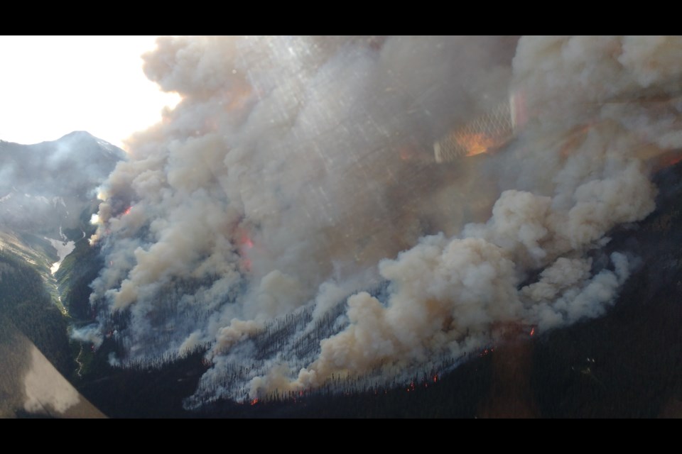
Lightning strikes start most of the wildfires in Kootenay National Park, including the prominent ones of the past 20 years such as the 2003 Tokumm-Verendrye blaze, the 2017 Verdant Creek fire, the 2018 Wardle Creek fire and this spring’s Mitchell Ridge fire.
“When I look at the numbers in the last 20 years, including the 2003 fire season which was quite significant in Kootenay, there’s been about 34,000 hectares burned, so about 24 per cent of the park,” said Charlie McLellan, fire and vegetation specialist for Lake Louise, Yoho and Kootenay field unit.
“But if I compare that to our historic fire regimes, it’s only slightly more than that. Historically we would expect around 30,000 hectares during that period to burn so it’s probably more representative of what these ecosystems would have looked like historically.”
Up until the early 2000s, there was very little fire in the previous 80 years in Kootenay National Park, with the exception of the 1968 Vermilion fire that burned 1,500 hectares in Kootenay and 500 hectares in neighbouring Banff National Park.
But there were more before that based on direct evidence of fire, which can be found in scarred trees, burned stumps or logs, or charcoal in the duff layer of the soil.
“It does seem like a lot of it is burnt in the last 20 years, but it’s probably more representative of what a lot of these ecosystems would have looked like historically,” said McLellan.
Studies have shown that due to decades of fire suppression and climate change, the natural fire regime has been altered from a more frequent low to moderate fire regime to less frequent but higher intensity fires.
For example, the 2003 Tokumm-Verendrye fire in Kootenay, which was dubbed “The Holy Shit” fire, burned approximately 16,000 hectares, 41 per cent resulting in high burn severity.
According to a 1989 fire regime study by the parks service of the day, “fire is pervasive” in Kootenay National Park.
It found the mean fire return intervals for the Kootenay and Sinclair and Vermilion areas ranged from 92 to 165 years, respectively, and from 75 to 267 years for the Vermilion Valley prior to and after 1768. The mean fire return interval for the whole park was 127 years.
“Virtually all forests in the park have burned at some time; charcoal was even found at 2,400 metres elevation less than 750 metres from a glacier,” states the report.
Throughout the parks, a series of river valleys create pathways for fire spread. In Kootenay, for example, the Vermilion and Kootenay rivers facilitate fire spread north-south.
South-facing slopes in these valleys tend to have the biggest influence on fire behaviour, and combined with regional wind directions, create potential for large, high intensity wildfires.
Kootenay National Park has very diverse temperature and precipitation ranges, with the southern end of the park getting significantly less precipitation than the north in Vermillion Valley and is also 2 Celsius to 6 C warmer.
“This creates a longer fire season in the south of the park as snowmelt occurs in this area as early as March,” states the 2020 integrated fire management plan.
“Temperatures and precipitation in the north of the park are similar to Banff as they near the Continental Divide.”
Kootenay National Park also sees a lot more lightning-sparked fires, largely influenced by the Continental Divide and lifting of air masses as low pressure systems track from British Columbia into Alberta.
According to Parks Canada’s integrated fire management plan, the park typically experiences the highest number of lightning-caused wildfires over Banff and Yoho, with 71 per cent of all fires sparked by lighting accounting for 90 per cent of the total area burned.
Marie-Pierre Rogeau, a Banff-based independent fire history, ecology and behaviour expert with a PhD in fire regimes, said a distinct lightning shadow exists over Banff National Park, with lightning strikes dropping off east of the Continental Divide before picking up in the foothills.
“There’s two different fire regimes in the Rocky Mountains, and a lot of it divided by the Continental Divide,” she said.
Rogeau pointed to a 2002 scientific paper led by fire expert Jack Wierzchowski that examined the influences of fuel, weather and topography on lightning-caused forest fires in portions of southern British Columbia and Alberta.
The results showed a significant difference in lightning and lightning-caused fires east and west of the Continental Divide.
“He found to start one lightning fire in Alberta you need 1,400 strikes, but to start one lightning fire in British Columbia, you need 50 strikes,” said Rogeau.
“The why has never really been answered … but B.C. ignites a lot more easily than Alberta.”
Rogeau said the bigger fires of recent decades have been in the northern end of Kootenay National Park – such as Verdant and Tokumm-Verendrye. The 1968 Vermilion blaze also burned a big swath of land.
She said the southern end of the park burned more frequently 100 years ago or more compared to the northern end.
“I think the reason, in part, why they had such difficulty with these fires to the north was that the fires started over much older forest,” said Rogeau.
“When you have more fuel on the ground, it’s drier, there’s a lot more momentum and also if there’s no danger, they’re just going to let these fires go.”
In Banff National Park, along the east slopes of the Canadian Rockies, lightning and lightning-caused fires do not occur frequently.
Yet evidence from studies of fire history shows fires occurred frequently in the east in many of the montane and subalpine forests prior to the 1880s and the start of the era of European settlement and the construction of the railway.
According to studies, most of these fires burned during periods of infrequent lightning and before the typical season for major summer thunderstorms.
The difference in the fire frequency and season of burning is thought to be the result of burning by local Indigenous people to draw game species into the valley bottoms for food.
Overall, Rogeau said there are not as many lightning fires in southern Alberta as in BC.
“All of southern Alberta, including Banff, the foothills, it’s driven by human ignition, so anthropogenic burning,” she said.
Fires were suppressed for much of the 20th century in the mountain national parks, but new park policy over the last three decades means forest fires are allowed to burn under controlled conditions to fulfill their ecological role in national parks when safe to do so.
Despite restoration efforts over the past 30 years, however, monitoring still indicates that ecosystem health within the parks continues to decline due to these previous fire exclusion policies resulting in significant fire cycle deficits.
McLellan said the 2020 integrated fire management plan for Banff, Yoho and Kootenay – a blueprint for fire protection and fire restoration – has an objective to burn 50 per cent of the long-term fire cycle through the use of prescribed fires and carefully managed natural fires.
“There’s actually been more fire in Kootenay National Park than that 50 per cent,” he said.
“From an ecological standpoint, it’s quite beneficial.”
Parks Canada has been able to track the benefits of fires on wildlife species, in particular for grizzly bears that were fitted with GPS tracking collars as part of the 2010-15 study to look at bear mortality on the railway tracks in Banff and Yoho national parks.
At any given time, a minimum of 11-13 grizzly bears with GPS radio collars were being tracked by researchers, but overall about 25 throughout the course of the study.
“A lot of those bears actually selected areas within Kootenay that had burned in 2003,” said McLellan.
Heading into Kootenay National Park in the late summer and into fall, the bears would feast on various species, like huckleberry that grew in high densities in the burned locations.
“It shows the importance of having fire for certain species, opening up the canopy, allowing vegetation on the surface to fruit or become quite productive,” said McLellan.
This summer marks the 20th anniversary of the Tokumm-Verendrye fire, which began as two separate lightning-sparked fires before they merged into one, and burned 12.6 per cent of Kootenay National Park.
Highway 93 South was closed for several days at a time, and firefighters worked hard to protect the historic Kootenay Park Lodge as fire came dangerously close, burning the forest surrounding the 1923 lodge.
The fire doubled in size on Aug. 20, 2003, in a matter of hours and headed for the Bow Valley. However, a two-kilometre-wide emergency fire guard was bulldozed and the fire never went beyond the pass.
Under the right conditions, though, either the Tokumm Creek or the Verendrye Creek fires had the potential to leave the Vermilion Valley and enter the Bow Valley, where residents were on edge.
In 2017, a lightning ignited fire was discovered via a live satellite detection system in a 300-year-old spruce-fir forest in the remote Verdant Creek area of Kootenay National Park on July 15 in one of the worst fire seasons on record in B.C. Despite immediate and persistent firefighting efforts, this fire grew to 18,017 hectares over the next two months.
Completely burning down a backcountry warden cabin as 70km/h winds whipped up, the approaching fire led to the evacuation of several facilities, including Sunshine Village in neighbouring Banff National Park.
During that summer, Kootenay National Park experienced the highest fire danger since 2003 – the park’s last big fire year. With an average maximum summer temperature of 27 C, wind speeds reaching 70 km/h, and only 26mm of rain in July and August, the weather was prime for extreme burning conditions.
As a result, when lightning struck Verdant Creek the fire spread quickly in every direction. It burned east toward the Continental Divide, south into Assiniboine Provincial Park and west toward Highway 93 South.
When first detected on July 15, 2017, Parks Canada immediately sent helicopters to bucket water onto the fire. At 9 a.m., the fire was 10 hectares – about the size of 10 football fields.
By 2 p.m., it had grown to 10 times that size. The Verdant Creek wildfire had burned through the equivalent of 100 city blocks in just five hours. With the extreme fire behaviour in the first few days, it was not safe for crews to be on the ground, so helicopters were sent to bucket the fire in strategic locations until conditions improved.
“Like 2003, which was a significant fire year, this was a big year,” said McLellan.
On July 31, 2018, separate lightning-ignited wildfires quickly grew and on Aug. 1, two wildfires in the Vermillion Valley merged to form the Wardle wildfire complex.
Earlier this spring, lightning sparked a wildfire in the southern end of the park at Mitchell Ridge on May 17, 2023, but firefighters were able to extinguish and contain it at 288 hectares, including 45 hectares that spread onto neighbouring provincial lands in British Columbia.
The fire started during unseasonably dry, warm and windy conditions.
McLellan said at no time did the fire threaten buildings or other infrastructure, but said the concern was centred on the wildfire potentially jumping the Kootenay River and impacting Highway 93 South.
“It was good that we went full response on it so that we caught the fire while it was still relatively small and it didn’t become something we have to manage long-term,” he said.


