RODANTHE, N.C. (AP) — Hurricane Erin battered North Carolina’s Outer Banks with strong winds and waves that flooded part of the main highway and surged under beachfront homes as the monster-sized storm slowly began to move away from the East Coast on Thursday.
Forecasters predicted the storm would peak Thursday and said it will slowly weaken over the next few days while turning farther out to sea.
Tropical storm conditions were in effect over parts of the Outer Banks and the coast of Virginia, the National Hurricane Center in Miami said. In Bermuda, residents and tourists were told to stay out of the water with rough seas expected through Friday.
There was flooding along part of the North Carolina and mid-Atlantic coasts, the center said Thursday morning. Authorities predicted that the largest swells would whip up life-threatening rip currents from Florida to New England.
Big waves push water over roads
As Erin's outer bands brushed the Outer Banks, waves broke through dunes on Hatteras Island and swamped the main route connecting the barrier islands and swirled under a handful of stilted homes perched above the beach. Parts of Highway 12 remained closed Thursday, and Ocracoke Island's connection to its ferry terminal was cut off.
Melinda Meadows, property manager at the Cape Hatteras Motel in Buxton, said a door was ripped off a townhouse and some walls were knocked out.
“It's the force behind the water,” she told WRAL-TV.
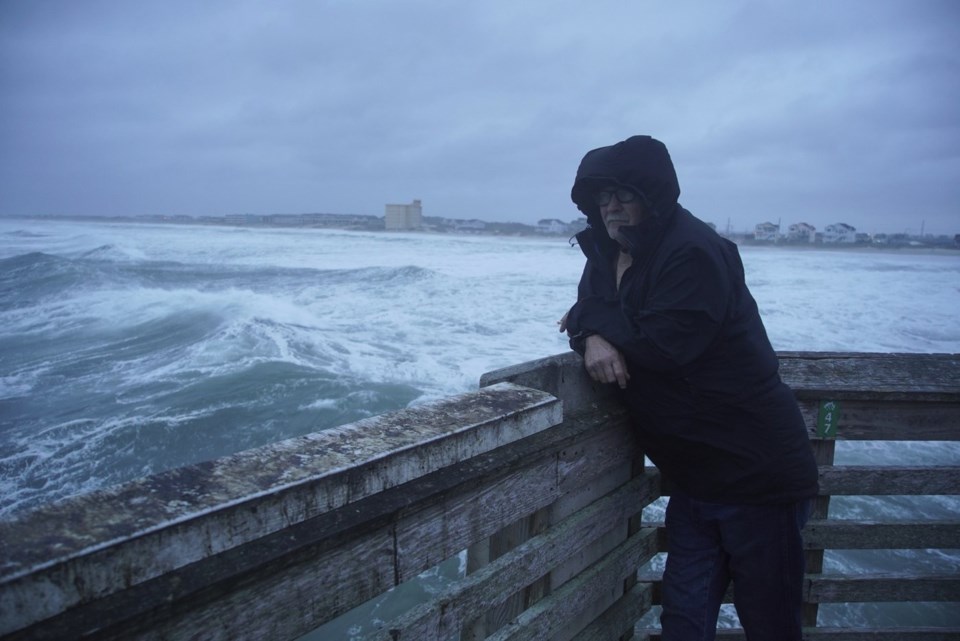
Farther north, on Jennette’s Pier in Nags Head where sustained winds reached 45 mph (72 kph) early Thursday, dozens of people were out taking photos of the huge waves crashing into the structure amid the driving rain. One man was fishing.
“This is nature at her best,” David Alan Harvey of Nags Head said Thursday morning. “I love this. I love these storms.”
He was unconcerned about being on the pier, saying he considered it safer than most other places. “Driving my car is a lot more dangerous than this.”
A few feet away, 23-year-old Daniel Irons, who lives in Hatteras, was bird-watching and waiting to see what new ones might be brought in by winds from the storm.
Beaches off-limits along the coast
Beaches were closed to swimming Thursday in New York City, and some others in New Jersey, Maryland and Delaware were temporarily off-limits. Widespread, moderate coastal flooding was forecast for low-lying areas of Long Island and parts of New York City.
Off Massachusetts, Nantucket Island could see waves of more than 10 feet (3 meters) this week.
Bob Oravec, a National Weather Service forecaster, said that even if someone thinks they know how to handle a rip current, it’s not safe.
“You can be aware all you want,” he said. “It can still be dangerous.”
Huge waves forecast to cause coastal flooding
Coastal flooding and erosion was a big worry in many beachfront communities. In North Carolina, waves were estimated as high as 18 feet (5.5 meters) Thursday morning, according to local weather reports.
Dozens of beach homes already worn down from chronic erosion and protective dunes were at risk, said David Hallac, superintendent of the Cape Hatteras National Seashore.
Most residents decided to stay despite evacuations ordered on Hatteras and Ocracoke Islands, which are increasingly vulnerable to storm surges.
“We probably wouldn’t stay if it was coming directly at us,” said Rob Temple, who operates sailboat cruises on Ocracoke.
The Hatteras Island Rescue Squad, a volunteer group based in Buxton, said it received no calls for rescues Wednesday night through Thursday morning.
Erin remains a large hurricane as it heads out to sea
The storm has fluctuated in intensity since first forming nearly a week ago, but it's still unusually large, stretching across more than 600 miles (965 kilometers) — twice as big as the average hurricane.
It remained a Category 2 storm Thursday morning with maximum sustained winds around 105 mph (165 kph), the hurricane center said. Erin was about 210 miles (340 kilometers) east of Cape Hatteras and moving away from the East Coast.
The hurricane center was also watching two tropical disturbances far out in the Atlantic that could develop into named storms in the coming days. With thousands of miles of warm ocean water, hurricanes known as Cape Verde storms are some of the most dangerous that threaten North America.
Climate scientists say Atlantic hurricanes are now much more likely to rapidly intensify into powerful and catastrophic storms, fueled by warmer oceans.
___
Seewer reported from Toledo, Ohio. Associated Press journalists Jeffrey Collins in Columbia, South Carolina; Gary Robertson in Raleigh, North Carolina; Ben Finley in Norfolk, Virginia; Kathy McCormack in Concord, New Hampshire; Dave Collins in Hartford, Connecticut; Hallie Golden in Seattle; and Julie Walker in New York contributed to this report.
Allen G. Breed And John Seewer, The Associated Press


