Westlock County will form a committee to oversee discussions and provide recommendations regarding Pembina River flood hazard area development policies going forward.
Councillors voted unanimously to form the temporary advisory committee on flood hazard matters, 6-0, at their Sept. 10 meeting which also included two well-attended public meetings regarding those policies in the county’s municipal development plan (MDP) and land-use bylaw (LUB).
The committee will consist of five public members and two members of council to make recommendations to council on changes to the MDP and LUB before Feb. 26, 2020. Two public members must reside outside of the flood hazard area and the committee cannot be chaired by either of the council members. There will be at least five meetings before the committee disbands at the end of April 2020.
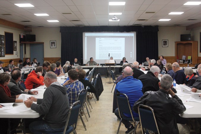
Prior to that decision though, council moved from their chambers to the Westlock Legion to accommodate more than 50 members of the public, many who wished to address council with their concerns and ask questions pertaining to the county’s development policies along the river.
CAO Leo Ludwig started the public hearing by going over some of the proposed changes for the municipal development plan in Bylaw 14-2019.
“The bylaw proposes to clarify a number of policy statements on development in the flood hazard area and remove the flood hazard area overlay (the draft LUB amending bylaw proposes to incorporate the overlay),” read Ludwig’s request for decision.
The bylaw also proposes minor changes regarding development adjacent to river banks and flood hazard areas. It also proposes changing the future land use map by removing the portion within the map that outlines the flood hazard area overlay.
Jim Wiese was first to the mic to say he was opposed to the changes for a number of reasons. He said that since the 1986 flood, which was considered to be a one-in-100-year flood, there has been a lot of flood mitigation done along the river, specifically the Paddle River Dam, which was completed in 1986.
“Now that the dam is in place, we may never have another flood on this river. They have a tremendous amount of capacity and Alberta Environment has the ability to monitor that capacity and how it flows into the Pembina River, so if we get a flood event, that dam will mitigate much of the problems that we have,” said Wiese.
Wiese also said the map has “no validity and would never stand up to a court challenge, because it’s not accurate.”
“If you continue to use a map that has no accuracy, you’re going to get a court challenge,” he said, adding he was all for taking the map out of the MDP, but not placing into the LUB.
Terry Sheehan, who first brought the issue to the attention of council two months ago, said he only had one issue with the amendments to the bylaw.
He stated he was not in favour of removing the overlay map, as he would then be left in a position where he wouldn’t be able to identify anything.
Other speakers echoed similar concerns, with some long-time residents questioning why their properties were even included on the flood hazard map in the first place.
The second proposed bylaw, Bylaw 17-2019, suggested amendments to the county’s land use bylaw.
CAO Ludwig once again provided an overview of the proposed amendments noting the bylaw aims to incorporate the flood hazard area overlay that was just removed from the municipal development plan, clarify requirements on development within the hazard area, provide definitions of flood-related terms, transition permitted uses within the overlay to discretionary and to provide specific exemptions to the constraints and prohibitions of development within the flood hazard area.
Wiese and Sheehan were again first to the mic for the second public meeting, which lasted for over an hour.
Wiese thanked council for the opportunity to provide them with more than 40 proposed changes a committee of affected landowners had decided upon, at a previous meeting of their own.
“We’ve spent considerable time on this,” he said.
“I think if you could separate what has happened before and what could happen in the future, we could get a clearer document. I don’t think anybody in this room is against having restrictions on subdivision development or acreage development that is intensified in a flood zone.”
The confusion, said Wiese, comes in where there are established yard sites, more than 100 years old, that have been through three major floods.
He used his own yard as an example, saying that the flood of 1944 taught his grandfather a thing or two and the yard was moved to higher ground in 1948.
“People have done one of two things. They’ve either moved their yard or they’ve mitigated the risk by building berms and a whole bunch of other measures to mitigate or eliminate the risk,” said Wiese, adding that county regulations could work to decrease the tax base in the county.
Eight others also spoke of their concerns.
Deputy reeve Brian Coleman, who attended the meeting by phone, initially called for a show of hands to gauge the public’s feelings, but retracted that after several objections from the crowd.
Instead he said council had all they needed to make a decision and the public meeting ended.
Back at council chambers, councillors discussed what they had learned at the public meetings and voted unanimously to accept the amendment bylaws for both the municipal development plan and the land use bylaw.
Coun. Jared Stitsen said he would like to see the bylaws approved quickly so landowners can move forward with their plans as soon as possible.
Coun. Fred Slobodian said, “If we go through with this it sends a message to the public that we’re honestly trying to make some progress. That’s the way I feel ... It’s important that we show the public we’re making some progress.”
Coleman agreed, “I think this council is committed to moving this forward to try to make it more feasible for business people to flourish on their farms.
Coun. Dennis Primeau finished the discussion before a motion was put on the floor.
“We’re actually doing something right here because public engagement is what it’s all about. We need to engage the public and get some proper information. That’s the process we should always be following,” he said.


