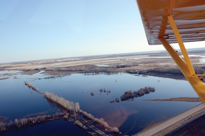
Westlock County’s week-long State of Local Emergency, which saw at least three bridges and 21 roads closed due to washed-out culverts, or being completely under water, is over.
The municipality declared a State of Local Emergency at 4:30 p.m. April 23 following reports of spring flooding causing roads and bridges to be washed out. Council voted 7-0 at its April 24 meeting to authorize administration to be able to access the municipality’s $381,759 disaster reserve to deal with problems that may arise and authorized repairs and evacuations. The declaration also allowed the county to borrow extra funds as needed.
Reeve Lou Hall thanked their employees for putting in long hours — some on call for 24 hours — to stay on top of the situation.
“(Thank you to) all of our employees at the county and any volunteers out there giving up their time and energies to help us battle this flooding issue,” she said.
“They are working to get it back to normal as quickly as possible. I think they deserve huge thanks for that.”
The state of emergency remained in place over the weekend and into Monday, April 30, but was not renewed for the coming week and was allowed to lapse at 4:30 p.m.
“The threat has passed for now and now it’s into recovery mode,” said chief administrative officer Leo Ludwig April 30.
“(Flooded areas are) leveling off in terms of the snow melt and some water levels have receded. Some roads can be repaired right away and others will have to wait until the waters recede”
Priority was given to dead-end roads that would result in people not able to access their property. Arterial roads were next, followed by collector roads and local roads.
Road breaches that can be repaired were fixed with field stone — rough slabs of 7.62 centimetre thick material that creates a stable surface — but some had to wait until the water receded because the culverts also needed to be replaced.
Anyone driving over field stone is advised to use extreme caution and take their time.
Bridge inspections were also carried out, though high-water levels prevented inspectors from looking under them.
Ludwig stressed that if a road was closed, it meant it was dangerous to drive on and that drivers should respect any barriers.
“Don’t move them. Don’t drive around them. It is not safe,” he said.
The county is also keeping a close watch on the Pembina River, where most of the floodwater is expected to end up. Ludwig said from April 18 to April 26 it rose three metres.
“The snow melt in the mountains has not yet happened,” he said.
“That really has an impact on the Pembina River. From what we’ve been told, that mountain snow pack is roughly 150 per cent normal. There is a fair amount of snow to melt yet. The best-case scenario is a slow melt in the mountains.”
He added the county is assessing the situation daily.
Anyone who spots water running over a road or other hazards is asked to report it immediately to the county’s dedicated 24-hour report line at 780-307-4283.
Residents can visit www.westlockcounty.com for up-to-date information. The Westlock News will continue to monitor the situation and post it to our website and Facebook page as it becomes available.
DIV. 1
• Landing Trail North of Twp 590
• RR 243 North of Twp. Rd. 592
• Twp. Rd. 594A between RR 243
and Twp. Rd. 595A
DIV. 3
• RR. 14 between Twp. Rd. 594 & 595A
DIV. 4
• RR 264 South of Highway 44
• RR 271 between Twp. Rd. 602 & 604
• RR 261 between Twp. Rd. 602 & 604
• RR 10 between Twp. Rd. 590 & 594
DIV. 5
• RR 245 at Twp. Rd. 602
• Old Highway 2 from Tawatinaw entrance to RR 243
• RR 250 between Twp. Rd. 612 & 614
• RR 253 between Twp. Rd. 610 & 604
• RR 252 between Twp. Rd. 610 & 604
• RR 233 North Twp. Rd. 615
DIV. 6
• Twp. Rd. 632 between RR 264 & 263
• Twp. Rd. 630 between RR 264 & 263
• Intersection of RR 270 & Twp. Rd. 632
• RR 632 West of Rge. Rd. 263
• RR 265, 1 mile North of Highway 663
(1/3 of road flooded)
• Twp. Rd. 614 & RR 265A
DIV. 7
• RR 272 South of Twp. Rd. 640
• RR 13A North of Highway 663
• RR 15 at Twp. Rd. 643
• RR 270 North of Highway 663
• Twp. Rd. 635 between RR 11 and 13
Div. 3
• BF 70813 - Bridge over Shoal Creek,
RR 21 North of Twp. Rd. 614


