ATHABASCA — It’s something many may not give a lot of thought to, but it’s very important for the future of the ecosystem and having access to healthy water.
The Athabasca Watershed Council hosted a State of the Riparian webinar June 29 with Shari Claire of Fiera Biological Consulting discussing the riparian area assessment of the Pembina River watershed, Mary Ellen Shain with the North Saskatchewan Watershed Alliance (NSWA) explaining the Riparian Web Portal and Lisa Card who works with landowners in the Pembina River Watershed through Highway 2 Conservation.
Riparian areas are transitional areas between the body of water and the upper limit of the floodplain or the uplands and based on Alberta’s hydrography data it is estimated the province has approximately 236,600 kilometres of lake shoreline and around 1.2 million kilometres of stream and river shoreline, counting both banks.
Claire, a biologist who has been working in Alberta for over 20 years, has developed practical tools and built information for improving land management and developing environmental policy. She has standardized the methods for mapping and assessing wetlands and riparian habitats using a geographic information system (GIS) and remote sensing technology.
“I just want to quickly define what we mean when we say riparian habitats,” she said. "Riparian habitats are found along the shorelines of all aquatic features. So, this includes lakes, it includes streams, rivers, creeks, wetlands, and riparian habitats are special and important because they're transitional areas between purely aquatic ecosystems and terrestrial upland systems.”
When the riparian is damaged or destroyed it can have a serious impact on the entire ecosystem as food supply is ruined, there’s no shelter for certain species of animals, reptiles or insects, migration routes are altered and it will increase floodwater velocity.
“If you're interested in managing riparian areas, or any natural habitat for that matter, one of the first questions you need to answer is how much do we have?” said Claire. “And this probably on the face of it seems like a really straightforward question. But actually, getting the answer to this question is not straightforward at all and it's because while we know that all aquatic habitats have riparian areas associated with them, we also know that the width of riparian areas varies considerably.”
The riparian management area (RMA) varies, but Fiera Biological Consulting uses a 50-metre buffer looking for completely intact riparian areas and locations free from disturbance.
“A loss of intactness occurs as a result of habitat fragmentation or degradation that is caused by human activity,” she said.
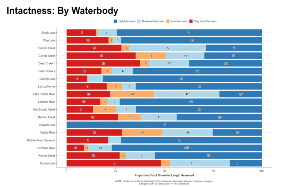
And while there are no legal requirements for setbacks to protect riparian habitats the 50-metre buffer, or setback, Claire said it is relevant and helpful with working with landowners who may be reluctant to give up a portion of their land by building a land cover classification ranging from high intactness to very low intactness.
For Romeo Lake, 38 kilometres southwest of Barrhead, it is in trouble with almost half of its riparian area defined as very low intactness. Even the Paddle River that runs past Jarvie, Dapp, Manola, and Barrhead only has high intactness along 86 kilometres of its 380 kilometres of shoreline – just over 25 per cent.
Shain explained the purpose of the Riparian Web Portal is collecting all of the data and how it shows a large swath of land from north of Edmonton to south of Red Deer and provincewide with the most damage to riparian areas.
“So, the reason why the NSWA wanted to pursue this project, when we first started asking the question about what state is our watershed in, we had to come up with a suite of indicators to use as a metric for measuring the health of the watershed,” said Shain. “And riparian health was indicated as an important metric for that.”
Armed with the data the NSWA, other watershed councils and the public can lobby local governments to create bylaws and setback guidelines which exceed the provincial minimum.
“Then the third is to develop incentive and support programs to enable and assist landowners ... to restore damaged areas, and to reclaim riparian vegetation,” she said.
And as Claire collects the data and Shain assesses it, it is Card who is on the ground working with landowners and municipalities to extract the data and implement the policies and bylaws.
Highway 2 Conservation was formed through a partnership with the County of Barrhead, Westlock County, Athabasca County and recently Thorhild County to work with agricultural producers focusing on best-management practices and education, Card said.
“So, the program provides trees and labour to the agricultural producers at no cost,” said Card. “I buy all the trees; I plant them and it's at no cost to them. If fencing is required on one of the project sites, we utilize funding sources to provide it to them at very little cost … but the landowner is responsible for the labour to install.”
She pointed out the County of Barrhead has a unique program that pays cattle farmers $100 per acre up to five acres, or $500 per year, for up to five years for riparian restoration.
For more information on how Card can help go to https://www.highway2conservation.com/ or call her at 780-674-8069.


