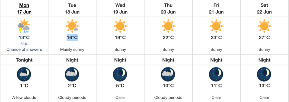
Last weeks wind and rain appears to have worked its way out of the region according to Environment Canada — the federal meteorologists are expecting a warm week for Athabasca, Barrhead, and Westlock, with temperatures peaking at 27 C Saturday.
First, everyone needs to make it through another dreary, overcast day. Expect sporadic showers with the possibility of thunderstorms throughout the rest of your Monday. About 30 per cent of the area will see some rain. The expected high is 13 degrees, and winds are blowing northwest between 20 and 40 kilometres per hour. The evening low will dip to a measly plus-one, with a risk for frost.
Tuesday will be mainly sunny although some lazy leftover clouds may be in area. The weather is slowly getting warmer though, and the UV index is going to be a moderate 5 or more with a high of 16 C.
Wednesday is going to be sunny, although it’s always wise to leave an umbrella in the car just in case. The high is creeping towards 20 C, although it’s expected to peak at 19 C.
Thursday will break that 20 C barrier, with an expected high of 22 C, and this weekend should be a scorcher — highs of 23 C, 27 C, and 26 C are expected for Friday, Saturday and Sunday.
Historical highs and lows
All data is from 2008-2023.
June 17: High of 25.8 C in 2019, low of 4.1 C in 2010
June 18: High of 27.1 C in 2018, low of 6.2 C in 2014
June 19: High of 28.3 C in 2018, low of 4.0 C in 2017
June 20: High of 28.3 C in 2010, low of 5.6 C in 2008
June 21: High of 28.2 C in 2018, low of 4.6 C in 2023
June 22: High of 29.2 C in 2021, low of 4.9 C in 2013


